New Iredell County Digital Flood Maps Available for Review

Last Updated 1/17/2024Posted in Stormwater, Latest City News, Homepage

Iredell County – Iredell County will host a Public Open House on Monday, February 5th, 2024, from 5:00 pm – 7:00 p.m., at the N.C. Cooperative Extension - Iredell County Agricultural Center 444 Bristol Dr, Statesville, NC

On Monday, February 5th residents and business leaders in Unincorporated Iredell County, the City of Statesville, the Town of Mooresville, and the Town of Troutman, will be able to review and discuss the latest update to their flood hazard and flood risk data. This public open house meeting will provide an opportunity for citizens and other stakeholders to see the results of the revised studies and new flood hazard areas, ask questions about the revised studies and the National Flood Insurance Program, and understand the requirements for submitting appeals or comments to the revised studies. County and municipal employees will be on hand to help residents locate their properties from the flood hazard data and determine their level of flood risk. Representatives from the North Carolina Floodplain Mapping Program will be available to answer questions about the hazard data update process, flood insurance coverage and floodplain management.

Residents also can access the flood hazard data online at http://fris.nc.gov/fris/.

NOTE TO EDITORS: For more information on the public meeting, contact: Milton Carpenter, NCFMP Outreach Planner, 919-825-2302 or Randall Moore, Stormwater Program Manager, City of Statesville Stormwater Division, at (704)761-2385.

View additional details on the upcoming Public Information Meeting: Determine Your Level of Flood Risk


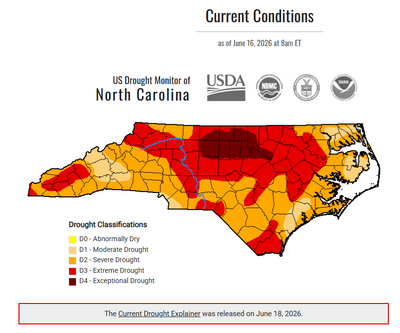
The North Carolina Drought Monitor map, updated June 18, 2026, shows worsening drought conditions across much of the state. Large portions of central and northern North Carolina are shaded red and dark red, indicating extreme (D3) and exceptional (D4) drought conditions. Much of the remainder of the state is experiencing severe drought (D2), shown in orange, with smaller areas of moderate drought (D1) in tan. According to the North Carolina Drought Management Advisory Council, City of Statesville water customers remain under D2 severe drought conditions, and water restrictions remain in effect. The map includes drought classifications and data from the USDA, National Drought Mitigation Center, NOAA, and partner agencies.
City of Statesville Remains at Stage 2 Water RestrictionsThe City of Statesville has reduced its water shortage response level to Stage 2 following improved drought conditions and guidance from...
An orange utility marker and exposed service line stand beside a neighborhood sidewalk, indicating underground utility or infrastructure work in progress. A quiet residential street lined with trees and well-kept lawns stretches into the distance on a sunny day.
Fiber Optic Installation Planned in the Cloaninger Avenu... The City of Statesville has approved a Right-of-Way Encroachment Permit for Ripple Fiber to install underground fiber optic conduit and ...
City of Statesville Invites Community to Celebrate at St... The City of Statesville invites residents and visitors to celebrate the stories, traditions, and cultures that have shaped our community...
Front & Center: Keeping You Informed of City of Statesvi... Weekly updates from the desk of April Nesbit, Public Information Officer for the City of Statesville. Continue reading for updates for t...
CANCELLED: Statesville Historic Preservation Commission ...
Jul 23, 2026
7:00 PM EDT
227 S. Center Street.
Statesville, NC 28677
Read More 
Statesville ABC Board Meeting
Jul 28, 2026
11:00 AM EDT
Statesville, NC
Read More 
Statesville Housing Authority Meeting
Jul 28, 2026
5:30 PM EDT
110 West Allison Street
Statesville, NC 28677
Read More 
Statesville Planning Board Meeting
Jul 28, 2026
6:00 PM EDT
227 S. Center Street.
Statesville, NC 28677
Read More